
Why Stormwater Plans Make Topographic Surveys More Important for Property Owners
What Does a Topographic Survey Show?
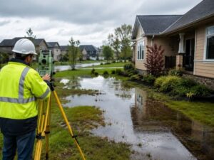
A topographic survey shows the shape and elevation of the land. It maps slopes, hills, low spots, drainage paths, driveways, and other surface features. Builders, engineers, and property owners use this information before construction starts.
Heavy rain causes more problems today than it did years ago. Streets flood faster. Water stays longer in yards. Soil washes away after storms. Some homes even deal with standing water after normal rain.
Cities now spend millions on stormwater projects. They improve drains, replace pipes, and build larger retention ponds. Still, many property owners ignore one thing that affects drainage on almost every property: elevation.
That is why a topographic survey matters more today.
Many drainage problems start years before flooding becomes visible. They often begin when somebody changes the land without understanding how water will move later.
Small Elevation Changes Can Cause Big Problems
Water always moves downhill.
A yard may look flat, but most properties have small elevation changes. Even a few inches can change where water flows during heavy rain.
One side of the yard may sit lower than the rest of the property. A driveway may push water toward the home. A fence may block drainage. New grading on a nearby lot may also redirect runoff.
Without accurate elevation data, many property owners do not notice these problems until damage appears.
That creates frustration.
Some homeowners spend years fixing wet spots, dead grass, or standing water. The problem keeps coming back because nobody checked how the land drains.
A topographic survey helps solve that problem.
Surveyors collect elevation points across the property. They create a map that shows how water moves over the land. Engineers and contractors then use that information before building starts.
Older Neighborhoods Often Have More Drainage Problems
Older neighborhoods often face bigger drainage problems today.
Years ago, many communities had fewer homes and less pavement. More rainwater could soak into the ground naturally.
That has changed.
Today, many areas have wider roads, larger driveways, and more buildings. Water now moves faster across the surface because less soil absorbs rainfall.
That puts more pressure on storm drains during heavy storms.
Water from one property can also affect nearby homes and yards. A drainage issue on one lot may slowly create problems for neighbors too.
Cities continue improving stormwater systems, but private property still affects how water moves during storms.
That is one reason many homeowners order a topographic survey before changing their property.
Small Projects Can Still Change Water Flow
Many people think only large projects need a topographic survey. That is not true.
Small residential projects can create drainage problems too.
A new driveway may redirect water. A patio may block runoff. A garage addition may raise the grade of the yard. Even landscaping changes can affect drainage.
Contractors need accurate elevation information before work begins. Without it, water may flow toward the home instead of away from it.
That mistake can become expensive later.
Some property owners only notice the problem after construction ends. Water may collect near the foundation or flood parts of the yard after every storm.
A topographic survey helps prevent those problems before work starts.
Many cities also require grading or drainage plans before approving permits. Engineers use topographic survey data to prepare those plans.
Without accurate survey information, projects may face delays.
FEMA Flood Maps Are Only One Part of the Picture
FEMA flood maps help identify large flood-risk areas. Still, they do not show every drainage problem on a property.
A yard may still flood because of poor grading, blocked runoff, or low spots in the land.
Many buyers check FEMA flood maps before buying property. If the home sits outside the flood zone, they often assume the property has no flood risk.
That is not always true.
A topographic survey gives a closer look at the shape of the property. It helps identify low areas where water may collect before flooding becomes obvious.
This becomes even more important in low-lying and coastal areas where small elevation changes affect drainage in a major way.
A Topographic Survey Helps Buyers Avoid Surprises
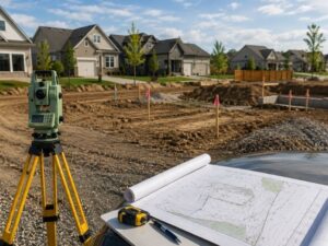
A topographic survey helps buyers understand drainage and grading conditions before purchasing property.
Many buyers focus only on the house itself. They inspect the roof, kitchen, flooring, and paint. Few think about drainage before closing.
That can become costly.
A property with drainage problems may later need grading work, drain pipes, retaining walls, or erosion repairs. Those repairs can cost thousands of dollars.
A topographic survey helps buyers understand the land before purchasing the property.
Commercial buyers often order these surveys because drainage problems can delay development plans. Residential buyers benefit from them too, especially when buying older homes or vacant land.
Stormwater Rules Continue to Change
Cities now pay closer attention to drainage problems because flooding continues growing in many areas.
Many local governments now require better grading plans and stronger stormwater controls before approving projects. That means more permit reviews and greater attention to elevation data.
Some property owners feel surprised when a small project suddenly requires drainage information. Still, cities face growing pressure to reduce flooding and protect roads and public infrastructure.
Because of that, accurate survey data matters more than ever.
A topographic survey helps property owners prepare before construction begins. It can also reduce delays during permit review.
Why Property Owners Should Pay Attention
Stormwater problems continue growing in many communities. Heavy rain now puts more pressure on roads, neighborhoods, and drainage systems than it did years ago.
Cities continue updating their stormwater plans because these problems keep getting worse.
Property owners should pay attention too.
A topographic survey helps people understand how water moves across their property before drainage problems become expensive repairs. It gives builders accurate elevation data before construction begins. It also helps buyers avoid major surprises after purchasing land or a home.
Many drainage problems begin years before flooding becomes visible. They often start when somebody changes the land without understanding how water will move later.
Fixing drainage problems early usually costs far less than repairing water damage later. A topographic survey gives property owners a better understanding of the land before construction or grading begins. That information helps reduce mistakes, lower repair costs, and prevent future drainage problems.
For a free land surveying quote, call us at (727) 295-4195 or send us a message by going here.
Posted in land surveying, land surveyor | Tagged topographic survey St. Petersburg