Topographic Survey vs. Boundary Survey: Which One Do You Need?
Developers order the wrong survey type more often than anyone in the industry likes to admit. They look for a boundary surveyor when they need a topographic surveyor, or they skip the topo entirely and hit expensive problems once grading starts. Both mistakes cost money and time.
A topographic surveyor and a boundary surveyor does completely different work. Knowing which one you need before you call a licensed surveyor will save you from paying for a second survey later.
What a Boundary Survey Does
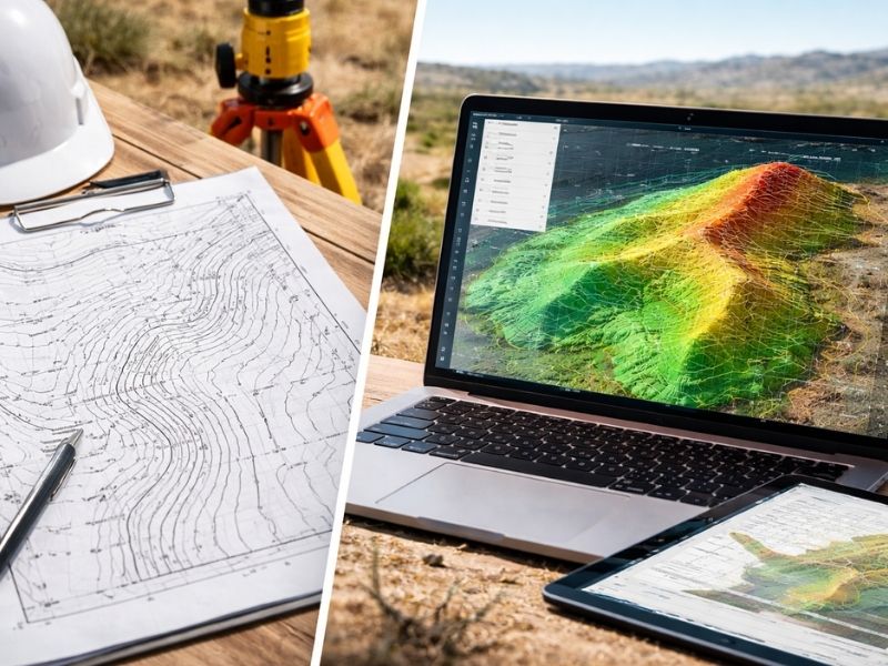
A boundary survey establishes the legal edges of a property. It locates corners, measures distances between them, and produces a map showing exactly where your lot begins and ends.
It answers one question: where is the line?
Surveyors research deed records, plat maps, and prior surveys before setting foot on the property. They locate existing monuments, set new ones where needed, and produce a signed, sealed document that holds up in court, at the permit office, and during a title review.
A boundary survey does not tell you anything about what’s happening on the ground inside those lines. It won’t show you drainage patterns, slope changes, or elevation differences. That’s not what it’s built for.
When Developers Need a Boundary Survey
- Before purchasing raw land to confirm you’re buying what’s described in the deed
- When an adjacent property owner disputes where the line falls
- Before filing for subdivision or lot splits
- When a title company flags an unresolved boundary issue
- Before any construction requiring a setback determination
If your project involves legal line questions, you need a boundary survey.
When Developers Need a Topographic Survey
- Before designing site plans for new construction
- When planning grading, drainage, or stormwater systems
- Before adding a pool, addition, or major landscaping change to an existing property
- When an engineer or architect requires elevation data before starting design work
- When the site has significant slope, low-lying areas, or drainage concerns
If your project involves building on the land or changing its surface, you need a topographic survey.
The Key Difference Between the Two
A boundary survey tells you where the property ends. A topographic survey tells you what’s inside it.
They serve separate purposes and produce separate documents. One does not replace the other.
Many developers assume that because they already have a boundary survey, they’re covered. They’re not, if site design work is starting. An architect needs contour lines and elevation data to design a building that won’t flood, won’t require excessive grading, and won’t violate drainage codes. A boundary map alone won’t give them that.
Do You Ever Need Both?
Yes. And on most development projects, you’ll need both.
A combined boundary and topographic survey is standard practice for new construction on raw or subdivided land. The boundary survey locks in the legal edges of the parcel. The topographic survey documents everything within those edges. Together, they give your design and engineering team what they need to move forward without costly surprises mid-project.
Some licensed surveyors can conduct both surveys during the same site visit, which reduces cost and turnaround time. Ask about this before scheduling separately.
What Happens When Developers Skip the Topo Survey
Site grading goes wrong. Drainage flows toward the building instead of away from it. Retaining walls end up taller than planned because no one accounted for the actual slope. Utility lines get placed in the wrong location because the elevation data wasn’t there to guide placement.
All of those problems are fixable. None of them are cheap.
A topographic survey costs a fraction of what it takes to correct grading errors after construction starts. Regrading a site mid-build can run tens of thousands of dollars depending on scope. The survey that would have prevented it costs a small fraction of that.
How to Know Which Survey to Order
Ask your project team two questions before calling a surveyor.
First: do we have confirmed, legally documented boundary lines for this parcel? If the answer is no or you’re not sure, order a boundary survey.
Second: do we have elevation and surface data for the site that our engineer and architect can use for design? If the answer is no, order a topographic survey.
If both answers are no, order both at the same time.
If you’re buying raw land, doing due diligence before closing, or dealing with a boundary dispute, start with the boundary survey. If you’re moving into active design and site planning, add the topographic survey before your architect starts drawing.
Don’t wait until someone asks for it. By then, you’re already behind.
Frequently Asked Questions
Can a topographic survey replace a boundary survey?
No. A topographic survey maps surface conditions and elevation. It does not establish legal property lines and can’t be used for title, permit, or legal boundary purposes. You need a boundary survey for that.
How long does each survey take to complete?
Turnaround time varies by property size, terrain complexity, and surveyor workload. A boundary survey on a standard residential or small commercial lot typically takes one to two weeks. A topographic survey on a larger or more complex site can take two to four weeks. Combined surveys may take longer but save time compared to ordering them separately.
Which survey does a lender or title company require?
Lenders and title companies typically require a boundary-based survey, such as a lot survey or mortgage survey, to confirm the property description and identify encroachments. A topographic survey is a design tool and is generally not part of the closing requirement.
Does a topographic survey show property lines?
Some topographic surveys include boundary information, but only if the surveyor is asked to include it and is licensed to perform boundary work. Always confirm with your surveyor what the deliverable will include before the job starts.
What does a topographic survey cost compared to a boundary survey?
Costs vary based on property size, terrain, location, and required detail. Topographic surveys are often priced higher than boundary surveys for the same parcel because they require more field time and data processing. Getting quotes for both at once is the most efficient approach.
For a free land surveying quote, call us at (727) 295-4195 or send us a message by going here.
Posted in land surveying, land surveyor |