
Drone Land Surveying for Large Parcels Before a Site Concept Is Finalized
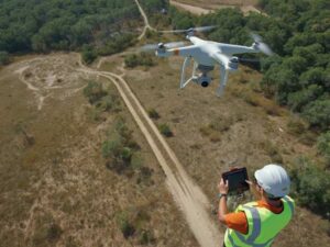
A hundred-acre parcel outside St Petersburg looks straightforward from a satellite image. Walk it on foot and you find wetlands tucked behind tree lines, slopes that don’t show up on old maps, and drainage patterns nobody documented. Drone land surveying solves this by capturing the whole site quickly, before your team locks in a site concept that might not actually fit the land.
For developers working large tracts, this step changes how early planning decisions get made.
Drone land surveying gives you accurate survey data across a full parcel in days, not weeks. Use it before finalizing a site concept, and you avoid designing around conditions that don’t match reality.
Why Large Parcels Need a Different Survey Approach
Walking a five-acre lot takes an afternoon. Walking two hundred acres takes days, and a lot still gets missed. Thick brush, standing water, and uneven terrain slow down ground crews and hide details from view.
A drone covers the same ground in a single flight. It captures elevation, vegetation, and drainage data across the entire parcel, corner to corner, without anyone needing to physically reach every section on foot.
What Drone Data Actually Shows Before Design Starts
Before your team sketches a site concept, drone survey data answers questions that usually stay unanswered until much later in the process.
This includes:
- Elevation changes across the full parcel, not just a few sample points
- Vegetation density and where clearing will be heaviest
- Low areas that hold water after rain
- Existing access paths, old roads, or trails cutting through the site
- Rough boundary alignment to confirm against recorded plats
Seeing all of this before design work begins means your concept gets built around real conditions, not assumptions.
Catching Site Problems Before They Become Design Problems
A site concept built on incomplete data often runs into trouble once fieldwork starts. A planned building pad sits on a slope nobody measured. A road layout crosses a low spot that floods every summer.
Drone data catches these issues early. Your design team can shift a building pad, reroute a road, or adjust a drainage plan while it’s still just lines on a screen. Once construction starts, the same fix costs far more.
How Drone Surveying Speeds Up Early Planning
Large parcels used to mean long timelines just for initial data collection. Ground crews walking acre after acre take time, and thick vegetation slows that process even more.
A drone flight over a large parcel typically wraps up in a single day, sometimes two for very large sites. The data processing afterward takes longer, but the field time itself shrinks dramatically compared to a full ground-based approach.
This speed matters most when:
- You’re evaluating multiple parcels and need to compare them quickly
- A deal has a tight due diligence window
- Your team needs preliminary data to pitch a concept to investors before committing to full engineering work
Combining Drone Data With Traditional Survey Work
Drone surveying does not replace a licensed boundary survey. It works alongside one.
A typical sequence looks like this:
- Drone flight captures the full parcel and general terrain conditions
- Design team uses this data to rough out a site concept
- A licensed surveyor confirms exact boundary lines and any easements
- Final engineering work builds on both data sets together
Skipping the drone step means your design team works blind during the earliest, most flexible phase of planning. Skipping the licensed survey step means you have no legal foundation for anything you build.
What to Ask Before Ordering a Drone Survey for a Large Parcel
Not every drone operator handles large acreage well. Ask specific questions before booking a flight.
- How many acres can you cover in a single flight?
- What format will the elevation and vegetation data come in?
- Can you flag low-lying areas that may hold water after rain?
- How long does data processing take after the flight?
- Can this data be shared directly with our design and engineering team?
A vague answer to any of these is a sign to keep looking.
Reading the Data Without Getting Overwhelmed
Raw drone data can look like a wall of numbers and layers if you’re not used to it. Ask for a simplified summary alongside the full data set.
A useful summary usually includes:
- A single overview image of the full parcel
- A basic elevation map showing high and low points
- Notes on any visible drainage issues or standing water
- A rough estimate of clearing needed based on vegetation density
This gives your team something to work from immediately, while the full data set stays available for engineers who need the finer detail.
When to Schedule the Flight in Your Timeline
Order the drone survey as early as possible, ideally before your team starts sketching layouts. Waiting until after a concept exists means any changes the data reveals force a rework instead of a first draft.
A good target is right after a parcel enters serious consideration, whether that’s during a purchase negotiation or right at the start of an internal feasibility review.
Frequently Asked Questions
How many acres can a single drone flight typically cover?
This depends on the drone equipment and site conditions, but many operators can cover a large parcel in one day, sometimes needing a second day for very large or heavily wooded sites.
Does drone land surveying replace the need for a licensed boundary survey?
No. Drone data gives a broad overview of terrain and site conditions, but a licensed surveyor is still needed to confirm exact legal boundary lines and easements.
Can drone surveys detect drainage problems on a large parcel?
Yes. Elevation data from a drone flight can show low-lying areas likely to hold water, which helps flag drainage concerns before a site concept locks in a building layout.
How long does it take to get usable data after a drone flight?
Processing time varies by provider and the size of the parcel, but many turnaround times range from a few days to about a week for large sites.
Is drone surveying useful if we’re comparing several parcels before deciding which to buy?
Yes. It provides a fast way to compare terrain, vegetation, and drainage conditions across multiple sites without sending ground crews to inspect each property individually.
For a free land surveying quote, call us at (727) 295-4195 or send us a message by going here.
Posted in land surveying, land surveyor | Tagged Drone Land Surveying