
How LiDAR Mapping Is Used in Floodplain and Stormwater Management
Flooding doesn’t wait for a hurricane. Heavy rain, poor drainage, and low-lying land create flood problems on ordinary days. If you’re developing in a flood-prone area, water management isn’t something you address after breaking ground. It shapes every decision before you get there.
LiDAR mapping gives developers the ground-level data they need to make those decisions with confidence.
This article explains what LiDAR mapping is, how it’s used in floodplain analysis, and why it matters when you’re planning stormwater infrastructure on a new site.
What Is LiDAR Mapping?
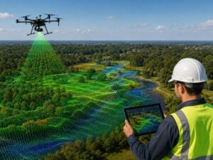
LiDAR mapping uses laser pulses fired from a plane or drone to measure ground elevation with high accuracy. It creates a 3D terrain model that shows how water moves across land. Engineers and developers use this data to identify flood risks, design drainage systems, and meet FEMA permit requirements.
LiDAR stands for Light Detection and Ranging. A sensor fires thousands of laser pulses per second toward the ground. Each pulse bounces back. The sensor records the return time and calculates the exact distance. Repeat that across an entire site, and you get a dense grid of elevation points called a point cloud.
The result is a bare-earth model accurate to within 10 to 15 centimeters. That level of detail is what floodplain work actually requires.
How LiDAR Reads a Floodplain
It Sees the Ground, Not the Trees
Standard aerial photos show what sits on top of the land. Rooftops, tree canopy, pavement. LiDAR filters all of that out. It captures the bare ground underneath, including low spots, berms, drainage swales and channels that aerial images miss completely.
Flat terrain makes this especially critical. A 6-inch elevation difference can decide whether a site drains or floods. LiDAR picks that up. A standard survey often won’t catch it at that resolution.
It Tells You Where the Water Goes
Accurate elevation data lets engineers run hydraulic models. Those models simulate rain events and track water movement across a site. They show which areas collect water first, which drainage paths get overloaded, and where ponding builds up after a storm.
For developers, this answers the question that matters before you buy: does this site flood?
FEMA uses LiDAR data to update its Flood Insurance Rate Maps. If your project sits in a Special Flood Hazard Area, your engineer is likely already pulling from LiDAR-based elevation data to support your permit applications.
How Developers Use LiDAR Data
Site selection. Many counties and municipalities offer LiDAR datasets through public GIS portals at no cost. Before spending money on due diligence, you can review flood zone boundaries, drainage patterns and site elevation. That’s valuable information to have before you’re under contract.
Permit support. Most development projects in flood-prone areas require a stormwater management plan requirements. LiDAR-based topographic data speeds up that process. Your engineer gets accurate base data faster than a full ground survey provides, which can cut weeks off your pre-permit timeline.
Elevation Certificates. If your project sits in or near a Special Flood Hazard Area, you’ll need an Elevation Certificate. LiDAR data supports the survey work behind it. A licensed surveyor still has to sign the final document, but LiDAR gives them an accurate starting point.
Flood mitigation design. LiDAR helps engineers size and position retention ponds, swales and drainage structures correctly. Guessing at grades is expensive when corrections come after construction.
LiDAR and Stormwater Management
LiDAR mapping gives engineers the precise elevation data they need to design stormwater systems that work. It shows how runoff moves across a site, where it collects and where it needs to go. Developers use this to build drainage infrastructure that meets local regulations and keeps finished construction dry.
Most municipalities now require detailed stormwater management plans for new development. Those plans rely on hydrologic and hydraulic modeling. That modeling is only as good as the terrain data underneath it.
LiDAR gives engineers a solid base. Your civil engineer can model exactly how runoff from your site connects to the surrounding drainage network. If your project adds load to a system that’s already near capacity, you’ll know before the local authority sends your plans back for revision.
Regional water management agencies across the country also use LiDAR for watershed-level flood modeling. If your project sits near a regulated water body, the permit review process may reference LiDAR-based data directly. Knowing this early saves time and avoids surprises during agency review.
What LiDAR Data Won’t Tell You
LiDAR is accurate, but it has real limits.
It doesn’t show underground infrastructure. Pipes, culverts and catch basins don’t appear in a bare-earth model. You still need a utility survey for that.
It can’t tell you how well a drainage system is maintained. A clean catch basin and a clogged one look identical in elevation data.
Data goes stale. LiDAR datasets get updated periodically, but some areas carry older collection data. A site that looked fine on a dataset from several years ago may have a different drainage picture today, especially in areas with recent development activity. Always check when the LiDAR data was collected before relying on it.
Frequently Asked Questions
Can I access LiDAR data for my development site for free?
Often, yes. Many county and state agencies publish LiDAR datasets through public GIS portals. The USGS National Map also provides free LiDAR downloads covering large portions of the country. Availability varies by region, so check your local and state GIS resources first.
Does LiDAR replace a traditional land survey?
No. LiDAR provides high-quality elevation data, but it doesn’t replace a licensed land surveyor. Boundary surveys, legal descriptions and Elevation Certificates still require a licensed professional to certify the work.
How accurate is LiDAR for flood analysis?
Most modern aerial LiDAR surveys achieve vertical accuracy within 10 to 15 centimeters. FEMA’s own mapping guidelines recommend LiDAR as the preferred terrain data source for flood studies, which reflects how reliable it is for this type of work.
Does FEMA use LiDAR data in its flood maps?
Yes. FEMA’s Map Modernization program uses LiDAR-based terrain data to update Flood Insurance Rate Maps nationwide. FEMA guidelines list LiDAR as the preferred source for base elevation data in flood hazard studies.
How does LiDAR support stormwater permit applications?
Most water management agencies require hydrologic and hydraulic modeling as part of a stormwater management plan. LiDAR-based topographic data provides the accurate terrain input those models need. Better base data means fewer review cycles and faster permit approvals.
For a free land surveying quote, call us at (727) 295-4195 or send us a message by going here.
Posted in land surveying, land surveyor |