
UAV Survey Before Designing Commercial Access Roads
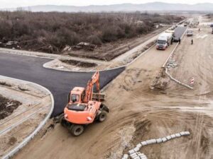
A commercial access road looks simple on paper. Then you add real ground, real drainage and real obstacles, and the plan gets complicated fast. A UAV survey captures the actual conditions along a proposed route before a single design line gets drawn. That early data can save weeks of rework later.
Mapping the Existing Ground Along the Proposed Access Road Corridor
An access road has to follow the land it sits on. A UAV survey captures elevations, grade changes and ground shape along the exact path being considered for the road.
This is not a wide, generic site map. It’s focused data collected specifically along the corridor where the road might go. Designers get a clear picture of where the land rises, where it dips and where it stays flat enough to build on without major regrading.
That focus matters. A road that ignores the ground it’s built on ends up needing expensive fixes down the line, from added fill to unplanned retaining walls.
Identifying High and Low Points That Affect Road Grades
Once the ground is mapped, elevation data shows where the road would climb, drop or cross a low spot. This directly shapes how steep the final road can be.
Commercial vehicles don’t handle steep grades well. A delivery truck struggling up a short, sharp incline is a problem you want to catch on a screen, not in the field. UAV elevation data lets designers spot these high and low points early and adjust the route before construction begins.
This stays focused on grade planning for the road itself. General site topography is useful too, but it’s a separate conversation from where this specific route climbs and falls.
Locating Ditches, Culverts and Drainage Crossings Along the Route
Water has to go somewhere, and a new road can block its path if nobody checks first. A UAV survey can capture visible ditches, culverts and other drainage features that sit along the proposed alignment.
Mapping these features early gives the design team real options. Maybe the road needs a culvert extension. Maybe the alignment shifts slightly to avoid a drainage channel altogether. Either way, the decision gets made with facts instead of guesswork.
This step doesn’t make drainage problems disappear. It just pushes them into construction, where fixes cost more and take longer.
Measuring Available Width Between Existing Site Constraints
A road needs room to exist. UAV mapping documents the actual space available between buildings, fences, drainage features and vegetation edges along the corridor.
This is about corridor width, not the layout of parking or loading areas. Those come later, once the road itself has a workable path. Right now, the question is simpler: does the space between existing obstacles actually fit the road being planned?
Sometimes the answer is no, and that’s valuable information too. Finding out early means the design team can adjust the route or the road width before anyone commits money to construction drawings.
Providing Existing-Conditions Data for Preliminary Access Road Design
All of this data feeds into one thing: a solid starting point for preliminary design. Engineers use the UAV survey to evaluate alignment options, check grades and judge whether the corridor is actually feasible.
The survey does not design the road. It hands over measured existing conditions, and the design team takes it from there. Elevations, drainage locations and available width all come from the flight data. The engineering decisions, like final alignment and grading, happen afterward.
This distinction keeps the process clean. Surveyors document what’s there. Engineers decide what to build. Mixing up those roles slows projects down and muddies who’s responsible for what.
Frequently Asked Questions
What does a UAV survey show before a commercial access road is designed?
It can provide terrain elevations, visible site features, drainage conditions and corridor measurements relevant to the proposed road route.
Can a UAV survey help identify steep sections along a proposed access road?
Yes. Elevation data shows changes in grade and helps designers see where the route may become too steep or need adjustment.
Can UAV survey data show drainage crossings along an access road corridor?
It can, when those features fall within the survey scope. Visible ditches, channels and culverts can all be mapped as part of the flight.
Does a UAV survey determine the final access road alignment?
No. The survey provides existing-condition data. The final alignment gets determined later, during engineering and design.
Why use a UAV survey before detailed access road design begins?
Early terrain and corridor data helps the design team compare route options. It also helps them avoid building a road layout around incomplete site information.
For a free land surveying quote, call us at (727) 295-4195 or send us a message by going here.
Posted in lidar mapping | Tagged lidar mapping