
Unmanned Aerial System Survey for Large Site Documentation
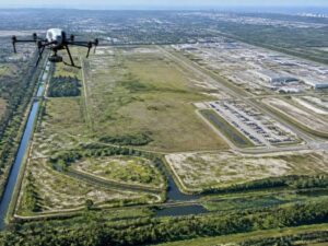
Picture a 200-acre property. Buildings sit on one end, open fields fill the middle, and a drainage ditch runs along the back. Now try to document all of it with a phone camera. You end up with hundreds of photos and no real way to connect them. An unmanned aerial system survey solves that problem. It flies over the whole property and captures one clean visual record from above. This post walks through how that record gets built, why it catches things ground photos miss, and how the data turns into files your team can actually open and use. If you manage large sites around St. Petersburg, Florida, this documentation method is worth knowing.
Building One Consistent Visual Record Across a Large Site
Ground photos pile up fast. One person shoots the north lot, someone else grabs the parking area, and a third snaps the loading dock. The angles never match, the light shifts through the day, and half the shots have no clear reference point. An unmanned aerial system survey fixes this. The drone flies a planned path over the entire property and captures images at set heights with set overlap, so every part of the site gets the same treatment.
That consistency is the whole point. When the flight follows a grid, you get even coverage from edge to edge instead of random snapshots. A large industrial yard, a solar field, or a wide campus all land in one sitewide record. You can view the full property at once and trust that no corner got skipped. Before the flight, mark your boundary and any no-fly zones so the crew plans complete coverage the first time.
Capturing Site Features That Are Easy to Miss in Ground-Level Documentation
From the ground, you see one thing at a time. You can’t tell how the retention pond sits next to the access road, or how far the tree line stands from the fence. Aerial coverage shows all of it together in a single view. That wider angle makes the relationships between features clear.
One flight can capture buildings, paved lots, open land, access routes, drainage paths, and vegetation limits in the same dataset. Because everything sits in one image set, you spot connections you’d never notice on foot. Maybe a drainage swale runs closer to a structure than the plans suggested. Maybe an old access road still shows faintly through the grass. These details matter, and they slip away easily when you’re walking a big site with a camera.
Organizing Aerial Data So Different Parts of the Site Can Be Reviewed Later
Raw drone images alone won’t help much. A folder with 900 loose photos is just as messy as the ground-level pile you were trying to avoid. The real value shows up after processing. Software stitches the images together and builds products you can actually navigate.
An unmanned aerial system survey can produce orthomosaics, surface models, and point clouds. An orthomosaic is a single flat map of the whole site, corrected so distances stay accurate. Surface models show elevation and terrain shape. Point clouds hold thousands of measured points in 3D. With these products, you zoom straight to one loading dock or one corner of a field and review only that spot, with no digging through unrelated pictures. Ask your provider which of these outputs come standard so you know what you’re getting.
Creating a Baseline Record Before a Large Property Begins to Change
Big sites change. Clearing starts, crews grade the land, old buildings come down, or a maintenance project reshapes a whole section. Once that work begins, the original condition is gone for good. A baseline aerial record captures the property exactly as it stands before any of it happens.
That baseline is worth more than most people expect. It answers questions about what was there first, what shape the land was in, and where features actually sat. If a dispute comes up later, you have proof tied to a fixed date. Fly the site early, before the first machine rolls in, and you lock in a record you can always point back to.
Turning UAS Documentation Into Files Project Teams Can Actually Use
Documentation only helps when people can open it and work with it. A drive full of loose drone photos does almost nothing for an engineer or a planner. The goal is data that drops straight into the tools your team already runs. That takes formatting and indexing done on purpose, not a rushed handoff.
A strong unmanned aerial system survey delivers formatted aerial imagery, orthophotos, and files prepared for CAD and GIS work. Engineers pull the orthophoto into their design software. GIS staff layer the mapped data over existing records. Planners and property managers reference the same source without booking a fresh site visit. Ask for deliverables tied to a coordinate system, so everything lines up with the other maps and plans you already keep.
Frequently Asked Questions
What is an unmanned aerial system survey?
It’s a survey that uses a drone to collect aerial images and data across a property. The drone flies a planned path and captures overlapping photos from above. Software then turns those photos into maps, models, and measured datasets. The result is one organized record of the whole site instead of scattered ground shots.
How large a site can a drone survey cover?
Drones handle properties of many sizes, from a few acres to several hundred. Larger sites simply need more flights or a longer flight plan to reach full coverage. Crews split big jobs into planned grids so no area gets missed. For very large properties around St. Petersburg, a provider may spread the work across a few flight sessions.
What products does a UAS survey deliver?
Common outputs include orthomosaics, surface models, and point clouds. An orthomosaic is a flat, distance-accurate map of the site. Surface models show elevation and terrain shape, while point clouds store detailed 3D measurements. Many providers also deliver formatted imagery and files ready for CAD or GIS software.
Why capture a baseline record before construction or clearing?
A baseline record shows the property in its original state before any work changes it. Once clearing or grading starts, you can’t get that first condition back. A dated aerial record helps settle later questions about what was there and where features sat. It gives your team and any reviewers a reliable point of reference.
Can UAS survey data work with our existing maps and software?
Yes, as long as the data gets prepared for it. Ask your provider to deliver outputs tied to a coordinate system that matches your records. Orthophotos and mapped datasets then load directly into CAD and GIS tools. That way the survey lines up with the plans and files your team already uses.
For a free land surveying quote, call us at (727) 295-4195 or send us a message by going here.
Posted in land surveying, land surveyor | Tagged lidar mapping