What Is a Boundary Survey? A Homeowner’s Guide
Have you ever wondered exactly where your property ends and your neighbor’s begins? You are not alone. For homeowners, that question comes up more often than you might think, and a boundary survey is the legal way to answer it.
What Is a Boundary Survey?
A boundary survey is a legal measurement of your property lines, completed by a licensed surveyor. It shows exactly where your land starts and stops, based on your deed and official county records. The final result is a document called a survey plat.
A licensed land surveyor researches your deed, pulls historical records, and visits your property to find or place the markers that define your corners and boundary lines. Think of the survey plat as the official proof of your property lines, both on paper and on the ground.
According to the National Society of Professional Surveyors (NSPS), boundary surveys make up approximately 28% of all land surveying work in the United States, making them one of the most commonly requested survey types.
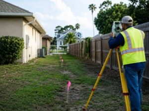
What Does a Boundary Surveyor Actually Do?
A boundary surveyor researches your deed and county records, visits your property to find or set physical markers, then produces a scaled legal drawing called a survey plat showing your boundary lines, corners, and any encroachments.
The process happens in three steps:
Step 1: Records Research
Before visiting your property, the surveyor reviews county records, your deed, historical plats, and documents from neighboring properties. In St. Petersburg and Pinellas County, many lots date back several decades. Older surveys, conflicting records, and worn-down markers are common here.
Step 2: Fieldwork
The surveyor visits your property to find existing markers, such as iron pins, concrete monuments, or other physical signs of where the boundary was originally set. If markers are missing or have been moved, precise measurements are used to re-establish them.
Step 3: Survey Plat
All findings are compiled into a scaled drawing of your lot. It shows boundary lines, lot dimensions, corner locations, easements, and any encroachments, such as a neighbor’s fence that crosses onto your land.
Worth noting: the 2026 ALTA/NSPS Land Title Survey Standards, which took effect on February 23, 2026, now require surveyors to document encroachments in a standardized summary table. This makes boundary issues easier to spot during real estate transactions.
Why Would a Homeowner Need a Boundary Survey?
Homeowners need a boundary survey before building near property edges, buying or selling a home, resolving neighbor disputes, or splitting a lot. It replaces guesswork with a legal record of exactly what you own.
Here are the most common reasons people in the area order one:
- Buying or selling a home. Some lenders require a current survey before closing. It is always smart to know what you are purchasing.
- Building a fence, addition, or shed. You need to confirm where your property ends before building anything close to the edges.
- Resolving a neighbor dispute. If you and a neighbor disagree about the property line, a boundary survey is the legal way to settle it.
- Subdividing land. If you want to split a lot into two parcels, a boundary survey is required by the county.
- Settling an estate. When property is inherited, a current survey makes it clear what is being passed on.
In St. Petersburg, older neighborhoods like Shore Acres, Historic Kenwood, and Roser Park often have small lots and aging records. Decades of informal assumptions about property lines are common. A boundary survey replaces those assumptions with documented fact.
Florida law allows a neighbor to claim ownership of your land through adverse possession if they have openly used it for at least 7 years without your objection. A current boundary survey and prompt action can prevent this.
What Is the Difference Between a Boundary Survey and Other Surveys?
A boundary survey focuses only on legal property lines. It is different from a topographic survey, which maps land features and elevations, and an elevation certificate, which is used for flood insurance. A mortgage survey is also less detailed than a full boundary survey.
Here is a quick comparison:
Survey Type | What It Does |
Boundary Survey | Defines legal property lines and corners |
Topographic Survey | Maps elevations, slopes, and physical features |
Elevation Certificate | Documents flood zone elevation for insurance |
Mortgage Survey | Basic sketch used for some loan closings |
A boundary survey is specifically about your legal property lines. It does not measure elevation or assess flood risk.
How Much Does a Boundary Survey Cost?
In St. Petersburg, a residential boundary survey typically costs between $500 and $1,500. The price depends on lot size, how complex the property history is, and whether original markers are still in place.
Factors that affect the price include:
- The size of your lot
- How complex your property’s history is
- Whether original monuments are still in place
- How long it takes to pull and reconcile historical records
It is one of the smaller costs in any real estate or construction project. It is almost always less expensive than the legal disputes it prevents.
Frequently Asked Questions
Do I need a boundary survey before building a fence in St. Petersburg?
Yes. St. Petersburg code requires structures to meet setback requirements from your property line. Without a current survey, you risk building in the wrong place, which can lead to fines or having to tear the structure down.
How long does a boundary survey last?
A boundary survey does not expire, but a lender or title company may require a new one if significant changes have occurred on or near the property since the last survey was done.
Can I use Google Maps or online parcel maps instead of a boundary survey?
No. Online maps and parcel viewers are estimates. They are not legally binding. Only a survey completed by a licensed Florida land surveyor is accepted in legal disputes, permit applications, and real estate closings.
What if two surveyors give me different results?
It happens, especially on older properties with missing monuments or conflicting historical records. A licensed surveyor is legally responsible for their findings and must follow Florida Board of Professional Surveyors and Mappers standards.
For a free land surveying quote, call us at (727) 295-4195 or send us a message by going here.
Posted in land surveying, land surveyor |