
UAV Survey Uses for Comparing Access, Parking, and Loading Areas
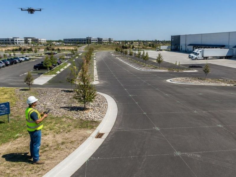
Getting a site plan approved is hard when your access points and parking counts keep changing. A uav survey gives developers a fast, accurate way to compare layout options before pouring any concrete. For projects in St. Petersburg, where lots are tight and tree canopy rules are strict, this data can save weeks of redesign.
Why Layout Decisions Get Messy Fast
Access, parking, and loading areas all fight for the same square footage. Move a driveway six feet and you might lose two parking spots. Add a loading bay and a fire lane might no longer fit.
Most teams try to solve this with old survey data or rough site sketches. That works until the county asks for a revised turning radius, or a tenant wants a bigger loading dock than the plan allows.
A current uav survey removes the guesswork. It gives you real ground conditions, not assumptions from a five-year-old plat.
What a UAV Survey Actually Captures
A drone flight over a site collects thousands of data points in minutes. This includes:
- High-resolution aerial photos
- Elevation data across the whole parcel
- Existing pavement edges, curbs, and striping
- Tree canopy and drip lines
- Drainage paths and low spots
Aerial Imagery vs Ground-Based Survey
Ground crews measure point by point. A drone captures the whole site at once, from above. You get a full picture of how access roads, parking rows, and loading zones actually relate to each other today, not just where property lines fall.
This matters most on infill lots, where existing pavement rarely lines up with old records.
LiDAR Mapping for Grade and Drainage
Lidar mapping adds a layer that photos alone cannot give you: precise elevation data. Every point on the surface gets a height value, down to a few centimeters in most cases.
For parking lots, that means you can check slope before a truck ever tries to back into a dock. For access drives, it means you can confirm a ramp will not exceed code before the final grading plan is drawn.
Comparing Access Point Options Side by Side
Most sites in St. Petersburg have more than one possible entry point. A corner lot might allow access from two streets. A commercial parcel might sit next to an alley.
UAV survey data lets you build a real elevation model for each option and compare them directly. You can check:
- Sight distance at each proposed entry
- Grade change from the street to the site
- Distance to the nearest intersection or driveway
- Conflict points with existing utilities
This turns a guessing game into a side-by-side comparison, backed by real numbers.
Sizing and Testing Parking Layouts
Parking counts drive a lot of approval decisions. Too few spaces and the plan gets kicked back. Too many and you waste land that could hold more building.
With an accurate base map from a uav survey, designers can test several parking layouts on the same site without sending a crew back out each time. You can shift aisle widths, test compact spaces, or try a different circulation pattern, all on one accurate model.
This is especially useful on odd-shaped lots, which are common in older parts of St. Petersburg.
Loading Dock and Truck Turn Checks
Loading areas need more than open space. They need the right grade, the right clearance, and enough room for a truck to turn without hitting a curb or a building corner.
Lidar mapping gives engineers the elevation detail needed to run truck turning templates against real site conditions. This catches problems early, like a dock apron that is too steep or a turning radius that clips a parking row.
Fixing that on paper costs far less than fixing it after paving is done.
Why St. Petersburg Sites Add Extra Layers
Local conditions make this kind of comparison even more valuable here:
- Many lots sit close to sea level, so small grade changes affect drainage fast.
- Tree protection rules can limit where pavement is allowed.
- Older neighborhoods often have narrow rights of way, which limits access options.
A drone flight captures all of these conditions in one pass, so design teams are working from the same accurate picture, not separate reports pulled from different sources.
Using UAV Data During Design Review
Once the flight is done and the model is built, developers can use it in a few practical ways:
- Overlay two or three access layouts on the same base map.
- Share a clean visual with the design team before a formal submittal.
- Flag conflicts early, like a loading dock that blocks a required fire lane.
- Update the model quickly if a layout changes, without a full re-survey.
This keeps the design process moving and cuts down on late-stage surprises during permit review.
Frequently Asked Questions
What is the difference between a UAV survey and a traditional survey?
A UAV survey uses a drone to capture site data from above, covering the entire parcel quickly. A traditional survey uses ground crews to measure specific points. Many projects benefit from using both methods, depending on the project’s scope and the level of detail required.
How accurate is LiDAR mapping for site design?
LiDAR mapping can capture elevation data with accuracy down to a few centimeters under suitable conditions. This level of detail supports grading plans, drainage design, parking layouts, and other site development decisions.
Can a UAV survey replace a boundary survey?
No. A UAV survey documents existing site conditions, terrain, and elevation, while a boundary survey establishes the legal property lines. Most commercial developments require both surveys to support planning and construction.
How long does a UAV survey take on a typical commercial site?
The drone flight itself often takes less than an hour for a standard commercial property. Processing the collected data into maps, point clouds, or surface models typically takes several days, depending on the size and complexity of the site.
Why does grade matter so much for loading areas?
Loading areas need relatively flat or gently sloped surfaces so trucks can load and unload safely. Excessive slopes can affect trailer stability, cargo handling, and dock operations. LiDAR data provides precise elevation information that helps designers identify and correct grading issues before construction begins.
For a free land surveying quote, call us at (727) 295-4195 or send us a message by going here.
Posted in land surveying, land surveyor | Tagged LiDAR Mapping